Start Grid Reference: 048119
Walk distance: 4.8 miles
Time: 3 hours (approx.)
From the station walk over the railway bridge and take the small road off of Dirker Drive. Very soon you will have good views over Marsden towards Wessenden Valley.
Moor view looking towards March Haig
The path over the moor is well marked. Follow it until a bench is reached. Take the path to the right in the direction of Cop Hill. As you pass a ruined cottage, moorland gradually changes to pasture. As soon as the road is reached turn immediately right down Shaw Lane.
Passing by the cottages, follow the way marked footpath sign down a narrow lane into a field. At this point, the path becomes very indistinct. Take a diagonal route across the field to reach the woods. The path through the woods is visible, but may not be seen immediately. Listen for the sound of water. That will lead you to the path and as you descend to the water you will see the waterfall.
Waterfall above Slaithwaite Hall
Cross the stream and follow the path to Slaithwaite Hall. This is a collection of cottages and as you follow the road through it to Marsden Lane, you will pass by the Hall itself.
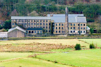
As you descend the Lane, you will have views into the valley particularly Cellars Clough Mill by the side of the canal - another mill soon to be converted to apartments.
When you reach the canal follow the towpath passed the Mill to the start of your walk.


No comments:
Post a Comment